
Navigating your way around Delhi is no less than finding your exit in a maze garden, but the Delhi metro route offers the perfect solution. Think of the Delhi metro map as your guide to the city because the rapid transit system connects South Delhi to North Delhi and West Delhi to East Delhi. The network has an average of 5.5 million passengers travelling daily, but the criss-crossed map might often leave you in a dilemma. Don’t you feel clueless about whether to take the magenta or yellow line to go to Qutub Minar? To help you decode the Delhi metro rail map, here’s a guide for you! Let’s go through the history of the Delhi metro, the key features of coloured lines on the map, and many more essentials.
Metro Network in Delhi: An Overview
The vast Delhi metro map, what we see today, was a lot different in 2002. Conceptualised in the 1960s, the construction of the metro route began in 1998. As the operation began between Shahdara and Tis Hazari in East Delhi, it became the second metro system in the country. The Delhi metro network rolled out Phase 1 ahead of schedule and under budget and turned out to be a success story.
- Today, the Delhi metro map serves 392 kilometres with 288 stations.
- The metro is the first railway project to claim carbon credits for regenerative braking.
- The Delhi metro NCR map stretches to Noida, Gurugram, Faridabad, Ghaziabad, Ballabhgarh, etc.
- On a single day in August 2014, the metro network in Delhi transported over 27 million passengers.
The metro route is planned to address the growing traffic in the bustling capital. Every line has a specific colour and prioritises passenger safety. Of course, the DMRC Delhi metro map is constantly evolving to cater to the increasing number of commuters; we will come to that later.
| Overview of Delhi Metro | |
|---|---|
| Owner | Delhi Metro Rail Corporation (DMRC) |
| Locale | National Capital Region (NCR) |
| Transit Type | Rapid Transit |
| Number of Lines | 10 |
| Number of Stations | 256 |
| Daily Ridership | 4.62 million (46.26 lakh, 2022-23) |
| Annual Ridership | 2.03 billion (203 crore, 2023) |
| Key People | Manoj Joshi (Chairman), Vikas Kumar (Managing Director) |
| Headquarters | Metro Bhawan, Barakhamba Road, New Delhi – 110001 |
| Website | delhimetrorail.com |
| Operation Start Date | 24 December 2002 |
| Number of Vehicles | 336 trains |
| Train Length | 4/6/8 coaches |
| Average Headway | 3 minutes |
| System Length | 350.42 km (217.74 mi) |
Also Read: Delhi Airport Metro Route, Timings and Fares: Things To Know
Key Features of the Delhi Metro Map
Once you get the hang of the Delhi metro rail map, you will figure out the most hassle-free way to navigate India’s capital. While colour-coded lines are the highlight of the map; you would want to know about other features. Here are some of the features to notice in the Delhi metro NCR map:
1. Colour Coding
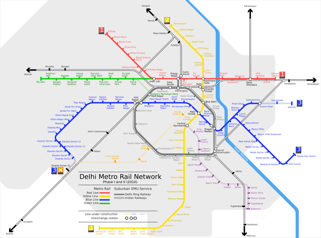
If you ever open the Delhi map with metro lines, you will see red, yellow, green, and many other coloured lines criss-crossing. The different colours are for you to identify your route and plan accordingly. Every line represents a connection from one area to another, with a focus on a user-friendly journey. Below, we mention the current route of Delhi metro map with lines and colours:
| Line Number | Colour | Route |
| 1 | Red | Rithala (North Delhi) – Shaheed Sthal (Faridabad) |
| 2 | Yellow | Jahangirpuri (West Delhi) – HUDA City Centre (Gurugram) |
| 3 & 4 | Blue | Dwarka Sector 21 (Dwarka) – Electronic City (Noida) |
| 5 | Green | Brigadier Hoshiar Singh (South Delhi) – Mukundpur (Indraprastha) |
| 6 | Violet | Kashmere Gate (Central Delhi) – Ballabhgarh (Haryana) |
| 7 | Pink | Majlis Park (North Delhi) – Shiv Vihar (East Delhi) |
| 8 | Magenta | Botanical Garden (Noida) – Janakpuri West (West Delhi) |
| 9 | Grey | Raja Nahar Singh (Bahadurgarh) – Dwarka (Delhi) |
| Airport Express | Orange | New Delhi Railway Station – Indira Gandhi International Airport |
2. Interchanging Stations
DMRC Delhi metro map clearly shows the location of all stations. You can see which line will take you to your destination along with the interchange stations. For instance, if you look at the Delhi metro red line map, you will see Kashmere Gate to be the major interchange point for connecting the red line with the Delhi metro yellow and violet lines.
Also Read: Kalindi Kunj Metro Station: An Overview, Metro Route & Fares
3. Symbols and Landmarks
Besides highlighting different lines and interchange points, the map mentions hospitals, bus terminals, railway stations, metro museums, etc. through symbols. So, let’s say, you are looking at the Delhi metro yellow line map, and you will see AIIMS highlighted with the hospital symbol.
Tools for Delhi Metro Map with Lines
Resources for the Delhi metro map are not only accessible at the stations but also online. Ensuring seamless navigation for everyone, you can find a high-quality Delhi metro map online, too. Find two online resources for the map below:
1. DMRC Website
The official website of Delhi Metro Rail provides accurate and up-to-date information. You can download the Delhi metro map in PDF, check real-time train arrivals, and use fare calculators. The website also shows station details with accessibility and other features and offers news about the Delhi metro map and fares.
2. DMRC Mobile App
Android and iOS users can access the Delhi metro route map on the go. The mobile has the same features as the official website, so you can check the map with lines and plan your trip. You can also check the travel time estimates and nearby stations.
Also Read: Jahangirpuri Metro Station: Map, Fare And Nearby Landmarks
Importance of the Delhi Metro Route Plan
The vastness of the Delhi metro network is overwhelming for first-time travellers and even seasoned Delhites. However, the well-planned map makes exploring the Hauz Khas via the yellow line or Nehru Place via the violet line a breeze. Here’s why understanding the Delhi metro map is crucial:
1. Time Management
Delhi’s notorious traffic can steal your precious time. Consider the NCR metro map as your holy grail to beat the congestion you might face on the road. By studying the map, you can find faster routes between your destinations and save hours.
2. Easy Exploration
Delhi is full of people from all walks of life; some are here to pursue higher degrees and dreams and others to witness architectural wonders. The DMRC metro network is the only budget-friendly option for unlocking your destinations. With stations strategically built all over the city, the route of Delhi Metro will inspire you to explore more.
3. Seamless Travel
Because of the interconnecting lines, the Delhi metro rail map visually shows the station you should get down to change the line. You can plan seamless transfers between lines and reach any part of the city. Plus, during peak hours, the gaps in metros range from 2 to 5 minutes. Outside the peak hours, the frequency is from 5-10 minutes. Either way, the Delhi metro timings are not very long but depend on the line and day.
Also Read: HUDA City Centre Metro Station: Route, Timings, Platforms
Tips for Efficient Delhi Metro Navigation
Overall, it’s safe to say that the Delhi metro network is modern and easy to use. The first time can feel a bit challenging, but it’s easy to navigate with a few tips. Here are a few useful tips to understand the Delhi metro map and navigate your way.
1. The first step is understanding the colour scheme.
2. Stations on the metro map are highlighted in circles or squares.
3. Always keep the interchange points in mind when you need to connect to other lines.
4. Use the interactive map with metro lines on the DMRC app.
5. Download a copy of the map to access route information if you don’t have internet access.
6. Ask the metro staff if you find the Delhi metro full map difficult to understand.
Also Read: Kashmere Gate Metro Station: Timings, Platforms, Entry-Exit
Future Plan for Delhi Metro
As said earlier, several expansions, including the Golden Line, are underway. The Delhi metro phase 4 map will soon add six lines over 103 kilometres and enhance connectivity within Delhi. Plus, the expansion prioritises connecting Delhi with neighbouring cities like Ghaziabad, Noida and Gurugram. Phase 5 may be added to the Delhi metro future map as it is in the planning stage — the line may connect the entire Delhi NCR from Rohtak to Sonipath.
Overview of Delhi Metro Phase IV Extension
The Phase IV extension will add around 85.86 km of new lines to the existing Delhi Metro Network. There will be six new corridors, and the three priority corridors are Aerocity to Tughlakabad (Golden Line), Maujpur to Mukundpur (12.58 km), and Janakpuri West to RK Ashram Marg (19 km). Moreover, the extension of the Pink Line by 12.55 km will create the first ring metro line in India. The estimated cost for Phase IV is around Rs. 8,399 crore, with funding from Union and Delhi governments. It is expected that the corridors will be completed by 2028.
In essence, the Delhi metro map is more than a board showing colourful lines connecting. After all, the metro network is the gateway to exploring a vibrant city! By decoding the colours and symbols, you can navigate Delhi with confidence. Use the Delhi map with metro lines whether you are a seasoned traveller or a first-timer. Delve into its details and travel from Pitampura to Ballabgarh like a true Delhite!
Also Read: Top 7 Posh Localities in Delhi For Renting & Buying
Frequently Asked Questions
1. What is the metro fare in Delhi?
Delhi Metro fares start from Rs. 10 and vary based on the distance travelled.
2. What is the route of the Blue Line Metro in Delhi?
The Delhi Blue Line Metro runs from Dwarka Sector 21 in the west to Vaishali in the east.
3. Which metro line goes to Gurgaon?
The Yellow Line of the Delhi Metro goes to Gurgaon.
4. What is the largest metro station in Delhi?
Kashmere Gate is the largest metro station in Delhi.
5. Is the metro available in Ghaziabad?
Yes, the Delhi Metro Red Line extends into Ghaziabad.
6. How many lines are there in the Delhi Metro network?
The Delhi Metro Map has 10 colour-coded lines, including Red, Yellow, Green, Blue, Magenta, Violet, Pink, and Airport Express Lines.
7. What are the Blue Line and Yellow Line in Delhi Metro?
The Blue Line and Yellow Line are two major routes in the Delhi Metro system, serving as vital transportation links across the city. The Blue Line stretches from Noida Electronic City to Dwarka Sector 21, featuring 50 stations that connect key areas in both Noida and Delhi, while the Yellow Line runs from Samaypur Badli to HUDA City Centre in Gurgaon, encompassing 37 stations primarily through central and south Delhi.
8. When was the Delhi Metro started?
The Delhi Metro began operations on December 24, 2002, with the inauguration of the first line, the Red Line. Construction of the metro system commenced earlier on October 1, 1998, marking a significant step in enhancing urban transportation in the National Capital Region.
9. How many stations are there on the Delhi Metro Map?
The Delhi Metro currently has a total of 289 stations across its extensive network. This system spans approximately 395 kilometres and includes 12 lines, making it one of the largest metro networks in the world


